By John Curtin Home Inspector
Content Approved and Protected
Following is a list and description of places to launch, paddle and rent
kayaks, canoes and paddle boards from Ft. Pierce to Boca Raton.... have fun!!!
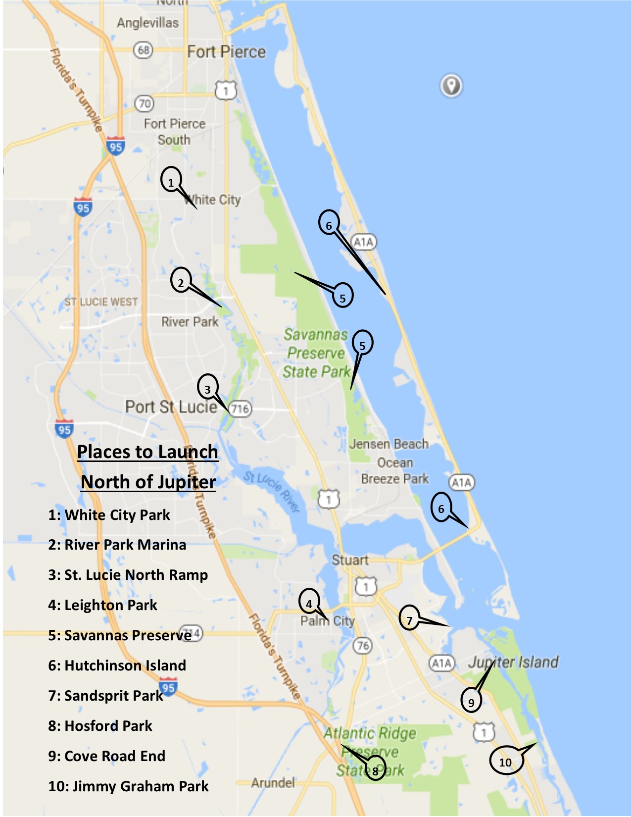
Ft Pierce, PSL & Stuart
White City Park
2081 W Midway Rd, Ft Pierce, FL
Kayak in the narrow, 50’+ wide, St. Lucie River with mangroves and scattered houses.
Head north approximately ½ mile to a narrow, 25’ wide, side river which meanders north for 3/4 mile and comes back to the main river.
River Park Marina
500 E Prima Vista Rd, PSL
Head north or south in the narrowing, 100+ ft wide, St. Lucie river through mangroves with side channels. No development or houses in this area.
St. Lucie River North Fork Ramp
2200 Veterans Memorial Parkway, PSL
Head north in the, 150’ wide, St Lucie River for 4000’ to a mangrove lined 20’ to 5’ wide creek on the right side which meanders north for over a mile before it rejoins the main river.
Head south for 2 miles through the main river and side channels until it opens up into the wider North Fork of the St. Lucie.
Leighton Park
2701 SW Cornell Ave, Palm City, FL
Head south from the west end of the Monterey Rd. bridge to the Veterans bridge where the river narrows and there some mangrove islands to navigate around and through
Savannas Preserve State Park
2541 Walton Rd. PSL, FL
There are numerous access points for this 10-mile-long Coastal Preserve Marsh offering open water and meandering trails through marshes.
Hutchinson Island
From Port Saint Lucie south to Stuart there are numerous pull offs and launch points where you can gain access to the Intracoastal’s mangrove lined shore and hideaways and the Spoil Islands along the main channel which offer sand beaches, fishing and wilderness camping.
 .
.
Sandsprit Park
3443 SE St Lucie Blvd, Stuart, FL
Head east into the open waters of the Intracoastal and north to some spoil islands for wilderness camping and fishing in the flats.
Head west into the Manatee Pocket and wander around the river front marinas, boat service business and stop in at a restaurant for a libation.
Hosford Park
7737 SW Gaines Ave, Stuart, FL (Kanner Hwy & I95)
Head south as the 50’ mangrove lined river turns into forested shores of the Atlantic Ridge Preserve with some pull off and access points until you reach the head waters of the river approximately 2 to 3 miles upstream.
Head north 3 miles through mangrove lined shores interspersed with homes until you reach the broader river and the Veterans Hwy Bridge.
Cove Road to St. Lucie Inlet Preserve State Park
East end of Cove Road Stuart, FL
Launch at the end of the road and go north or south across the Intracoastal to access the meandering channels and open bays which wind through St. Lucie Preserve State Park on the barrier island. A 5 to 6-mile round trip. At the south and north ends of the waterway you can land on a sandy beach and access the ocean; the rest is mangrove lined wilderness.
Jimmy Graham State Park
SE Gomez Ave, Stuart, FL (3 miles north of Hobe Sound)
Head north in the mangrove lined side channels then keep north in the broader main channel of the Intracoastal until you reach Pecks Lake where beach access and the ocean is available. A 2-mile round trip.
Meander locally through mangrove lined side estuaries and house and boat lined channels.
Jupiter & Tequesta
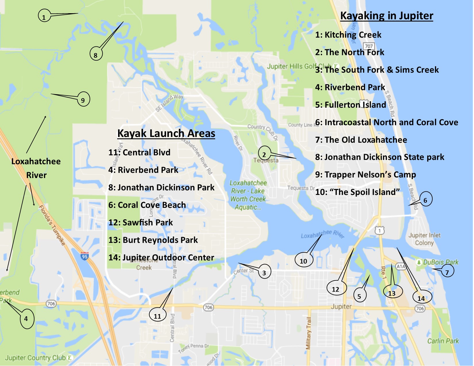
The Loxahatchee River 15 miles
The Loxahatchee River flows and meanders for 15 miles from Riverbend Park in Jupiter Farms to the Jupiter inlet where it merges with the Atlantic. At its head waters it is sometimes no wider than 20 feet and as it meanders and winds through the cypress canopied forest the paddler is transported back in time to when Florida was populated solely by indigenous Indians. There is the feel that one has been transported to the headwaters of the Amazon. An alligator is a sure site along with the possibility of deer, otters, wild boars, fox, turtles, otters, hawks, osprey and numerous other birds of the water and sky. Many paddlers bring a fishing pole. Within 1.5 miles of your journey’s start the Lainhart & Masten Dams are encountered. They were built in the 1930’s by local farmers of the same name for the purposes of irrigating their fields. The dams offer an exciting passage if the water is high. Welcome areas for picnic and rest areas are also available. At 2+ miles you will pass under the Turnpike and I-95. The river will have many different flows and feels depending on the time of day and the volume of water. At 5 miles you will come upon Trapper Nelsons Camp where a rest and tour is available. After passing Trapper’s the river will broaden and slowly turn from a canopied and wood lines stream to a mangrove lined river with dead cypress that supports osprey nests. At 7 miles Kitching Creek enters from the north and at 8 miles Jonathan Dickinson Park is reached. There, refreshments can be bought and a picnic enjoyed and your trip can end, or begin, at its boat ramp and rental facility. Canoe Outfitters of Florida which operates a rental facility at Riverbend park will pick you, and your rented or personal watercraft, up and transport you back to your car. You can also rent a variety of boats at Jonathan Dickinson Park. If you continue on you will pass the Tanah Keeta Boy Scout Camp and exit the “Wild and Scenic” portion of the river at 9 miles where river front homes will be seen. At 10.5 miles the river will widen with the feel of a small lake or bay and the now brackish water will begin to give way to the oceans tidal influence. At 13 to 14 miles, the rivers North Fork and South Fork will be encountered and will beckon exploration at a later time. You will also come across a “spoil Island” where canal dredging’s have been deposited. At low tide almost 1 foot of the island is exposed but by high tide it is covered by up to 3 feet of water. When the incoming tide is a few hours before high the crystal clear ocean water is a delight to swim in and at sunset it is a great place to enjoy the ever-changing colors of the sky and clouds—natures canvas. Don’t forget some shrimp and a bottle of wine. There are also 2 small mangrove covered islands which is a favorite overnight roost for local birds of all varieties. At 14 miles you will pass under a railroad bridge and enter the busy traffic at the intersection of the Intracoastal Waterway. Shortly you will go under US Highway 1 and pass the Jupiter Light House on the rivers’ north side. At 15 miles you will pass through the rock lined channel where the Loxahatchee flows into the Atlantic Ocean. At this point great care should be taken if there is an outgoing tide. When the out rushing waters of the Loxahatchee encounter the Atlantic it creates great turbulence with random waves reaching as much as 5 feet. Add to this boats of all sizes traveling at high speed to navigate the rushing waters and this is no place for the novice to be caught. Even if you have no intention of venturing beyond the inlet the swift currents can surprise the inexperienced paddler and at best make it very difficult to work your way back up the river to safety.
Tributaries of the Loxahatchee
Kitching Creek 2 miles
Head north from the launch at Jonathan Dickinson State Park for less than 1 mile and then turn north into the Kitching Creek tributary. The 20 foot wide Kitching Creek winds and meanders north for about 1 mile as it narrows until becoming impassable. Mangroves give way to tree lined shores and a canopy cover with some access points for exploring the areas around the creek.
The North Fork 4 miles
Just west of the Railroad Bridge follow the channel markers north and under the Tequesta Drive Bridge. The broad river will narrow as you approach the County Line Road bridge at 3 miles from the Railroad and AIA bridges where you began your journey. Shortly after passing under County Line Road houses will disappear as the river enters Jonathan Dickinson State Park. The last vestige of civilization is the Girl Scout Camp. Mangroves line the narrowing and winding river with occasional pine and oak trees which support osprey nests and all sort of fowl. You will pick a path around islands in the river which form a small maze of paths and after 1 mile your journey will eventually end in small pockets of thick and tall mangroves as the water continues to flow north into the park.
The South Fork 3.5 miles
At a little more than 1 mile from the A1A and Railroad bridges the South Fork will veer off to the left. The wide river will continue for another ¾ of a mile until it passes under the Loxahatchee River Road Bridge.
Just before the bridge, on the south side of the river, the two forks of Sims Creek will veer off under Central Blvd. These two forks wind through central Jupiter on their way to Indiantown Road. Houses with docks for small boats line the tree canopied river until both branches become too small to advance. The south branch can be explored for about 1 mile and the north branch about ¾ mile.
The main river continues west for another 1.5 miles narrowing to less than 75 feet as its straight course passes by houses and mangrove lined parks. Your journey will eventually end when you encounter the dam at the end of the C-18 Canal, Indiantown Road. Just beyond is I-95 and the Florida Turnpike. Where the river passes under Central Blvd. at approximately ¾ miles from its west end there is a parking area with a kayak launch.
 .
.
Other places to explore in the Jupiter area
Riverbend Park
9060 W Indiantown Rd, Jupiter, FL
Begin your trip on the Loxahatchee here.
There are 5+ miles of navigable waterways within the park. They include open water lakes, winding streams, marsh and grass lined waterways and cypress and tree covered hideaways. Hawks, turkeys, peacocks and all manner of water fowl can be observed along with deer, wild boars, fox and lesser mammals. And don’t forget to be wary of the alligators. In the middle of the park Chikee huts are accessible for picnicking. The waterways within the park are best enjoyed when the water level is high.
Intracoastal South, Jupiter Island Park, Fullerton and surrounding islands
Until the mid-1890’s the Intracoastal south of the Loxahatchee River was a meandering creek only passable in small boats. Henry Flagler dredged it producing the beginning of the open southern water highway we are familiar with today. The dredging left the area from the Loxahatchee to the Indiantown Road Bridge a maze of “spoil” islands and meandering river bends on either side of the new channel. Burt Reynolds Park is the largest feature in the area with its boat ramp. The water-way wrapping behind Burt Reynolds Park has three small coves to explore. To the west is Fullerton and two other islands which were created from the remains (spoils) of the dredging. In 2008 Palm Beach County purchased Fullerton Island and began its transformation by removing its interior land mass. It is now a 6-acre refuge featuring unique wetland and upland habitats for fish, birds and wildlife. The interior is only accessible to kayaks and paddle boards. The waterways around the islands also provide unique habitats to explore. Other mangrove hideaways are also accessible just south of Indiantown Road. East of Fullerton Island there is a small house lined channel which many of our commercial fishing boats call home.
Intracoastal North and Coral Cove 2 miles
Just west of the Atlantic Ocean the Intracoastal heads north and passes under Cato’s bridge to Jupiter Island. Before you reach the bridge on the west side there are beaches where you can land and swim. When the tide is high and “slack” there is excellent snorkeling around the bridge pilings and in the mangroves on the western shore. Just north of the bridge on the west side there is a tidal estuary which provides an excellent example of why these areas are considered the “Nurseries of our Oceans”. Slightly further north and on the east side there is a small island which you can paddle around. On the island’s east side the shallow waters are often homes to manatees and rays. You now approach Coral Cove Park on your east side. The sand beaches provide protected waters for many families who drive to the area. There shallow and sandy areas around the mangroves provide great places to explore and search out small fish. Across the channel and at the north end of the Coral Cove beach there is a sand bar which is exposed at low tide. This is a good place to explore where snails abound. A little more than a mile north of the Loxahatchee the County Line Sand Bar is found on the Intracoastal’s west side. On weekends you can see and mingle with over 200 boats of all shapes and sizes who flock here to enjoy the sun, sand, sights and sounds of Jupiter.
Jupiter Beach Park, The Old Loxahatchee 1 mile
On the south side of the Loxahatchee just west of Dubois Park and only 500 feet from the Atlantic a small estuary flows under a foot bridge. It winds through a protected beach area favored by families with small children and enters a larger estuary where you can explore around the island which houses the Jupiter Beach Pavilion, a large picnic shelter. Heading west you will pass under Jupiter Beach Road holding the mangroves at bay with your hands in the narrows before you enter into a 700 feet long estuary behind Ocean Trail Condominium. On the south end you will explore a 10 feet wide waterway which will pass under A1A and end at the west parking lot for Carlin Park some 1500 feet later.
Places to launch and Kayak in Jupiter
Riverbend Park (west)
9060 W Indiantown Rd, Jupiter, FL
Access to the Loxahatchee’s north end and Trappers Nelsons Camp and 5 miles of trails within the park.
Jonathan Dickinson Park (west)
16450 SE Federal Hwy, Hobe Sound, FL
Access to the middle of the Loxahatchee River, Kitching Creek, and Trapper Nelsons Camp.
Pine Glades Natural Area (west)
4122 West Indiantown Road, Jupiter, FL
Parking and kayak launch amid approximately 2 miles of recently reclaimed mesic flatwoods, wet flatwoods, wet prairie, depression marsh, and dome swamp.
Coral Cove (central)
Located on Jupiter Island 1 mile north of Cato’s Bridge on Bridge Road. Park along the road.
Sawfish park (central)
Located on the south side of The Loxahatchee on Alternate A1A / Hwy 811 on the east side of the road just before the bridge. Approximately 30 parking spaces with access to the Loxahatchee where the Intracoastal heads south.
Burt Reynolds Park (central)
805 N U.S. 1, Jupiter, FL on US 1 just south of the Loxahatchee.
Large parking and picnic area. The kayak launch area is located in the park on the east side of US 1 and east of the boat ramps and behind the public restrooms.
Central Blvd (central)
Head west on Indiantown Road and turn north on Central Blvd (less than 1 mile from I-95). In 1000 feet on the north side of the road before it crosses the Loxahatchee River there is a pull off where you can launch kayaks.
Bert Winters Park (south)
13425 Ellison Wilson Rd, Juno Beach, FL
Boat ramp giving access to the Intracoastal.
Juno Park (south)
2090 Ellison Wilson Rd, North Palm Beach, FL
Boat ramp giving access to the Intracoastal.
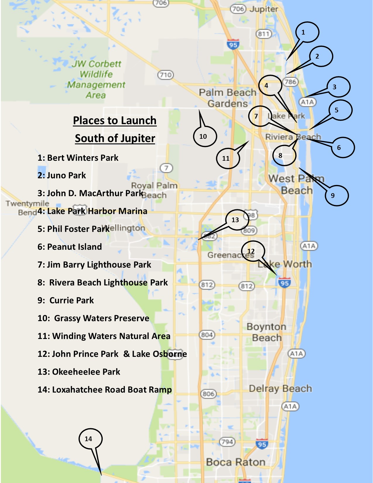
South of Jupiter
John D. MacArthur Park & Munyon Island (Intracoastal)
10900 Jack Nicklaus Drive North Palm Beach, FL
Rent a kayak or launch you own in the mangrove lined estuaries and bays just east of this Atlantic barrier island. Heading south you will work through shallow bays and islands towards Munyon and Little Munyon Island’s. Located to the east of the Intracoastal channel both mangrove and treed islands have sandy beaches and the larger island has some inner waterways to explore. It is about 1 mile to the southern Little Munyon Island. Passage through the inner bays can be shallow and difficult to navigate in extreme low tides.
Lake Park Harbor Marina
105 Lake Shore Drive, Lake Park, FL
Marina with launch facility on the west side of the Intracoastal. Head north to the Munyon Islands and south to Peanut Island.
Phil Foster Park & Scuba / Snorkel Trail (Intracoastal)
900 Blue Heron Blvd, Riviera Beach, FL
Along with a boat launch the park also sports an 800 feet long Snorkel and Scuba trail of artificial reefs along its south boundary under the Blue Herron bridge. From here you can kayak to Peanut Island.
Peanut Island (Intracoastal)
Located at the mouth of the Palm Beach Inlet, Peanut Island offers the kayaker sandy beaches, a quality snorkeling environment and interior passages on its west side. Launch at Phil Foster Park and head south for 3/4 mile or launch at Riviera Beach Marina for a short paddle east to the island. The waters around the island are busy with boat traffic. The island also has camping and trails for walking and bicycling. On the main land to the west is the Port of Palm Beach which support freights traffic. During the Cold War the Island hosted a shelter for President Kennedy.
Jim Barry Lighthouse Park (Intracoastal)
1800 Broadway, Riviera Beach, FL
Marina with boat launch on the west side of the Intracoastal with access to Phil Foster park and Peanut Island.
 .
.
Riviera Beach Marina and Bicentennial Park (Intracoastal)
200 E 13th St, Riviera Beach, FL
Offers access to Peanut Island.
Currie Park (Intracoastal)
2400 N Flagler Drive, West Palm Beach, FL
Boat launch just north of The Flagler Memorial Bridge offering access to the Intracoastal. Head south 1 mile to view and explore downtown Palm Beach.
Grassy Waters Preserve (west)
8264 Northlake Blvd, West Palm Beach, FL
Grassy Waters is the Everglades in our Back Yard. As part of the watershed for Palm Beach only guided kayak trips are available by reservation. There is also an interpretive center, miles of hiking trails and nearly 1 mile of boardwalk.
Winding Waters Natural Area (west)
6161 Haverhill Road North, West Palm Beach, FL
Kayak through a 3.4-mile loop of open water in mesic flatwoods, wet flatwoods, hydric hammock, depression marsh, wet prairie, and dome swamp. There are also nature trails and a boardwalk leading to an observation tower. Also offers paved and off road bike trails.
John Prince Park and Lake Osborne (west)
2700 6th Avenue South, Lake Worth, Florida
2520 Lake Worth Road, Lake Worth, Florida
4759 South Congress Avenue, Lake Worth, Florida
With 3 access points to launch from you can explore the small estuary of Square Lake and the larger 3-mile-long Lake Osborne.
Okeeheelee Park (west)
7715 Forest Hill Blvd, West Palm Beach, FL
Offering a freshwater open lake with some nooks and crannies. The park also offers on and off road biking trails and a water ski park.
Loxahatchee Road Boat Ramp (55 miles south)
15490 Loxahatchee Rd, Pompano Beach, FL
Explore the true Everglades by accessing the southern end of the Arthur R. Marshal Loxahatchee National Wildlife Refuge at a boat access to the Hillsborough Canal. These areas are mostly traversed by air boats and fresh water fishing boats. Be sure to bring a GPS as getting lost is easy.
On the North side of the levy you can kayak ½ mile east and up to 10 miles west with the levy on your south side and access to the true Everglades on the north. Meander and explore through the untracked vastness and uncountable small pathways and rivers through the island hammocks and sea of grass.
On the south side one trail heads south east in the heart of the tall grass. It forks and intersects some other trails which run very straight and average 20 feet wide and wander through an area approximately 6 x 6 miles. Another trail heads south parallel to Conservation Levee Greenway. This is a wider trail averaging 50 feet and meanders more than the other path with some small grass islands to navigate around and through. After approximate 2.5 miles it turns east to meet the levee where one can take a straight narrow path back to the trail head.
Where to Rent in Jupiter
Blueline Surf & Paddle Co.
997N A1A Jupiter, FL 33477
www.Bluelinesurf.com
561-744-7474
(Jupiter Inlet)
Jupiter Outdoor Center
1116 Love Street, Jupiter, FL 33477
www.JupiterOutdoorCenter.com
561-747-0063
(Jupiter Inlet)
Jupiter Pointe Paddle
18701 SE Federal Hwy, Tequesta, FL
www.PaddleInParadise.com
561-746-6691
(Palm Beach Martin Co. Line)
Beach Water Sports
17967 S.E. Federal Hwy. Tequesta, FL
www.bwsfl.com
561-745-6900
(Palm Beach Martin Co. Line)
Canoe Outfitters of Florida
9060 W Indiantown Road Jupiter, FL
www.CanoeOutfittersofFlorida.com
561-746-7043
(Jupiter Farms Riverbend Park)
Jonathan Dickinson State Park River Tours
16450 SE Federal Hwy, Hobe Sound, FL 33455
www.JDStatePark.com/Rentals
561-746-1466
(Jonathan Dickinson Park)
John D. MacArthur Beach State Park
10900 Jack Nicklaus Dr. North Palm Beach, FL
www.MacArthurBeach.org
561-776-7449 Ext 102
(John D. MacArthur Beach State Park)
Adventure Times Kayaks
521 Northlake Blvd, North Palm Beach, FL
www.KayakKayak.com
561-881-7218


